Sunday, January 31, 2016
Tuesday Update
Current SPC Outlook
Good morning everyone. I will not beat around the bush so I will dive right into things.
Based off current data (the 06z runs) I feel the threat for some severe weather is still
there for Alabama overnight Tuesday. The one thing is the overall tornado threat seems
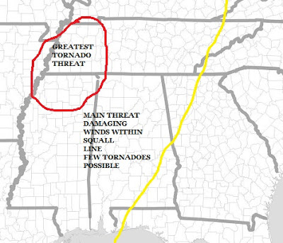
to be diminishing but not gone. Basically making the main threat for Alabama damaging straight line winds along the squall line.
INSTABILITY: Temperatures will be in the lower 70s and dewpoints in the lower 60s.
3pm 2meter temps
Dew Points at 6pm
The GFS and NAM are only indicating about 250-500 j/kg of CAPE from 3 p.m. to midnight window.
While yes this is more than enough to produce thunderstorm updrafts, but they won’t be intense.
GFS SB CAPE VALUES at 6pm Tuesday
NAM CAPE VALUES at 6pm Tuesday
WIND SHEAR: The overall wind shear needed for organized thunderstorms will certainly not be lacking
as bulk shear values will be over 60 knots. Low level helicity will be very high as well. The GFS
and NAM rate it at over 400 m2/s2, which is almost too high.
Bulk Shear
0-3KM SRH
The Significant Tornado Parameter is greater than 1 over Central Mississippi at mid-afternoon and nearly 2 over northern Mississippi by sunset, but goes down as the sun sets.
The entire system is a bit slower than this time 2 days ago. With this happening now the main area of concern for significant tornadoes will be north Mississippi and western Tennessee as storms in these areas could be supercells and will be occurring during the prime heating of the day. With that in mind I have adjusted my threat map accordingly.
Subscribe to:
Post Comments (Atom)


No comments:
Post a Comment